During our visit to Indio, California we had to get some hiking in, there are so many opportunities in the mountains, the desert and just outside of town. So we narrowed it down to three hikes during our stay, "The Slot" in Anza-Borrego State Park, East Indio Hills Badlands and Tahquitz Canyon. Each of theses hikes has its challenges but all three are so incredible beautiful and scenic you won't want to miss them.
As always be prepared wear sturdy hiking boots, bring plenty of water and snacks, sunscreen, first aid supplies and let your friends or family know where you are going and when you expect to return. Finally, check the weather forecast so you can dress appropriately and make an informed decision on whether to enter a slot canyon. Flash floods can be deadly if there is rain in the forecast or miles away, save the hike for another day.
"The Slot" is a narrow canyon in Anza-Borrego State Park. From Christmas Circle in Borrego Springs turn south on Borrego Springs Rd and drive 12 miles to Hwy 78. Turn left on Hwy 78 and drive 1.4 miles to Buttes Pass Rd, it a sandy dirt road on the left and there is a small sign. Follow Buttes Pass Rd to the ranger fee area ($10 per car) then to the parking area. The road is well maintained and accessible to passenger cars when it is dry. (GPS Coordinates 33° 10' 55.7"N 116° 12' 51"W )
Once you are down on the canyon floor follow the canyon to the left. As you continue the siltstone walls get taller and narrower. A tenth of a mile in and the canyon turns into a slot canyon. At this point you may need to hug the wall to let hikers returning to their cars through. Continue on to a rock slab forming the only natural bridge in the park (2nd picture above).
A little further and the canyon widens again, from here you can continue exploring to the Jeep road. We recommend returning the way you came because what is more fun then seeing a slot canyon... seeing a slot canyon again from the other direction.
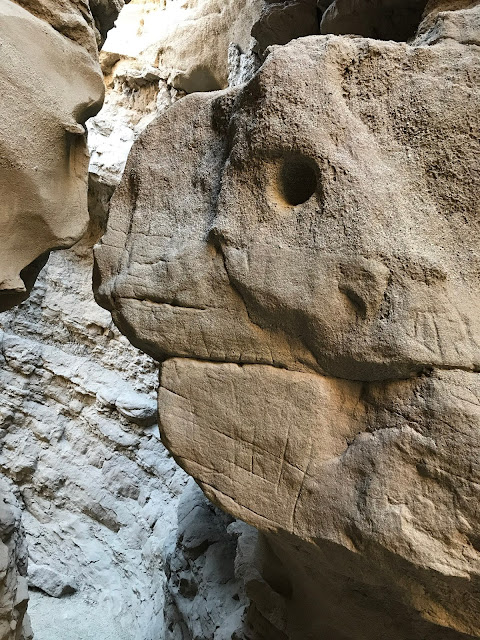
On your way back through the canyon to your vehicle try to spot this rock formation. We thought it looked like a turtle's head.
Address: 500 West Mesquite Ave Palm Springs, CA (GPS Coordinates 33° 48' 36"N 116° 33' 10"W) A large parking lot is available and at the visitors center you will pay an entrance fee of $12.50 per person and receive a trail map. This may seem a bit expensive but the fee helps to maintain the hiking trails and visitor center. You are also required to bring 32oz of water per person. The canyon is open daily from 7:30AM to 5PM.
East Indio Hills Badlands is a rugged 5.2 mile loop located 42000 Golf Center Parkway, Indio, CA. At the trail head there is a medium size parking area with overflow parking on the street. The parking area does fill up with local resident hiking shorter trails in the Badlands but we encountered very few people on the East Indio Badlands Trail Loop.
Due to the popularity of this area you want to avoid just following other hikers, look and follow the trail markers pictured above, they will point you in the right direction. It is good practice to have the next marker in your line of sight as you hike this trail, we also highly recommend the AllTrails App for this hike. The AllTrails App will give you directions to the trailhead, provide you with a trail description and most importantly use GPS to follow you along the trail.
There is absolutely no shade on this trail so remember a hat, sunscreen and plenty of water. Dogs are welcome on the trail but keep them on leash as we did cross paths with a coyote. As always bring plenty of water (for the dog too!), wear a good pair of hiking boots and check the weather. Do not attempt this hike if rain is in the forecast or if it is too hot out.
Please check out our Desert Art and Desert Hikes Video. You can find it under the video tab.
ADVENTURE ON |


No comments:
Post a Comment